South Lisbon Valley East
Highlights
- 292 Claims covering 5,850 Acres on the Colorado Plateau, Utah
- Road accessible — ~35 km northeast of Monticello, 2 km from the power grid, and 65 km from the White Mesa Uranium Mill in Blanding
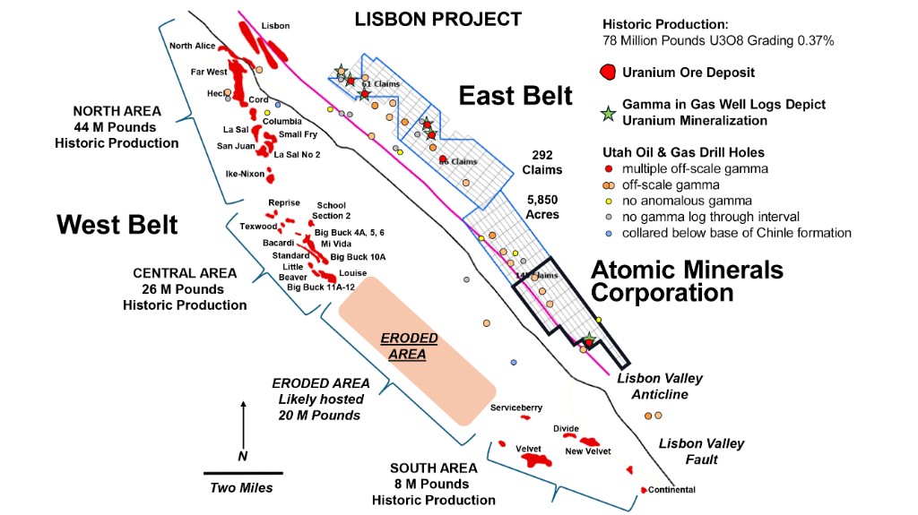
- Lisbon Valley historically produced 78 million pounds U₃O₈ at 0.37% grade — one of the highest-yield uranium districts in the U.S.
- Lisbon Valley ranks 2,153 tons of U₃O₈ per mile, among the most productive uranium belts in the country
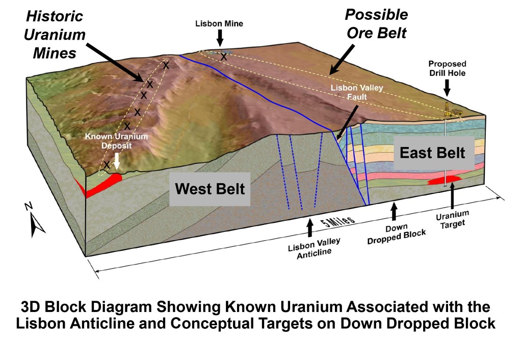
- Atomic property covers southern ±30% of the suspected down-faulted NE arcuate belt
- 51 historic oil and gas drill holes have defined the extent of the suspected belt
Overview & History
South Lisbon Valley East is located ~35 km northeast of Monticello, 2 km from the power grid, and 65 km from the White Mesa Uranium Mill in Blanding. The project sits within the Lisbon Valley district, an area historically recognized as one of the most productive uranium belts in the United States, with 80 million pounds of U₃O₈ produced between the 1950s and early 1980s from its 16 km southwest arcuate belt.
Atomic Minerals' claims cover the southern ±30% of a suspected down-faulted NE arcuate belt identified through historic oil and gas drilling. The table below illustrates Lisbon Valley's exceptional productivity relative to other major uranium districts in the USA.
| District | State | Miles Length | Tons per Mile |
|---|---|---|---|
| Southern San Juan | New Mexico | 90 | 2,559 |
| Lisbon Valley | Utah | 13 | 2,153 |
| Uravan | Colorado-Utah | 65 | 560 |
| Powder River Basin | Wyoming | 67 | 438 |
| Coastal Plain | Texas | 92 | 255 |
Geological Setting
- Hosted in the Triassic Chinle Formation, a major uranium-bearing unit on the Colorado Plateau.
- Historic drilling has defined an arcuate structural belt interpreted as the continuation of the Lisbon Valley trend but displaced to the northeast by faulting.
- The target horizon corresponds to zones where oil and gas wells recorded anomalous gamma activity.
Historical Exploration
51 historic oil and gas drill holes outline the down-faulted belt that underlies the project area. These gamma anomalies form the basis of the current exploration model. The Atomic Minerals claims strategically cover the portion of the belt with the greatest concentration of historic anomalous readings.
