Mont-Laurier
Overview
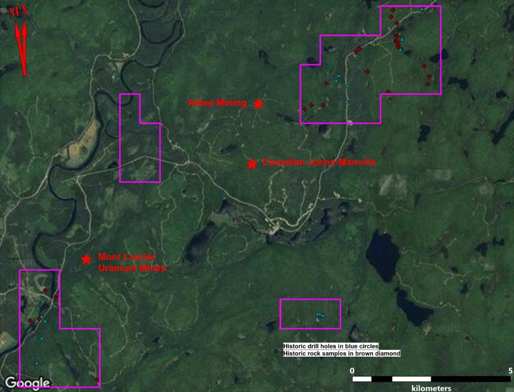
The 2,353ha road accessible Mont-Laurier project lies 40km NE of Mont Laurier. Exploration in the 1960's identified historic mineral resources at three deposits in the area. Mapping, sampling and diamond drilling identified a number of anomalous uranium values that were never followed up, including within the current Mont Laurier property boundaries. Uranium mineralization at Mont Laurier is hosted within gently dipping metasediments and metamorphic rocks.
Historic Resource Estimates
- Zone 1 (8.37 Mt @ 0.021%)
- Zone 2 (2.61 Mt @ 0.019%)
- Zone 3 (2.34 Mt @ 0.014%)
- Meekos (0.52 Mt @ 0.054%)
- Tom Dick (2.50 Mt @ 0.040%)
- Tom Dick Nord (0.30 Mt @ 0.027%)
All of the historic estimates are relevant as they attest to the potential of the Mont Laurier area and are assumed to be reliable as they were completed to the standards of the day. All of the above historic estimates would be considered inferred resource under NI 43-101. In all cases, verification of the historic drilling by twinning a series of holes would be required to verify each of the historic resource estimates. A Qualified Person has not done sufficient work to classify these historic resources as current mineral resources, and Atomic Minerals is not treating these historic estimates as current mineral resources.
1. Report on the Properties of Allied Mining Corporation and United Asbestos Corporation Limited, Leman Township, Montcalm County by J.D. Hagan March 31, 1970. (https://gq.mines.gouv.qc.ca/documents/EXAMINE/GM26044/)
The Allied historic estimates are based on 34 drill holes, totaling 5,091 feet (1,551.7 metres). The only key assumption, parameter or method provided in the report is that historic resources were calculated using cross sections.
2. Summary Report Covering Exploration For Uranium Mineralization During 1968-69 on Company Mining Claims in Ontario and Quebec by F.J. Evelegh, November 28, 1969 for Canadian Johns-Manville Co. Limited. (https://gq.mines.gouv.qc.ca/documents/EXAMINE/GM25420/)
The Meekos historic estimate is based on 184 drill holes, totaling 39,568 feet (12,060.3 metres). No details on key assumptions, parameters or methods were provided in the report.
3. Tom Dick and Central Groups, September 26, 1972 by R.F. Kaltwasser For Les Mines D'Uranium Mont-Laurier Inc. (https://gq.mines.gouv.qc.ca/documents/EXAMINE/GM28052/)
The Tom Dick historic estimate is based on 83 drill holes, totaling 15,000 feet (4,572 metres). No details on key assumptions, parameters or methods were provided in the report.
3. Les Mines D'Uranium Mont-Laurier Inc. Cantons Leman & Perodeau Campagne de Sondages Juillet - Septembre 1973 by G. Hébert and M. Vallée Le 21 décembre 1973. (https://gq.mines.gouv.qc.ca/documents/EXAMINE/GM29783/)
The Tom Dick Nord historic estimate is based on 11 drill holes, totaling 4,193 feet (1,278 metres). No details on key assumptions, parameters or methods were provided in the report.